Bar nearby Beer Colina
Coronavirus disease (COVID-19) Situation
confirmed cases
6400173
deaths
143200
Colombia
Bar nearby Beer Colina
Beer Colina
Carrera 58 #136-14, Colina Campestre, Bogotá Colombia
contacts phone
:
+57
Latitude:
4.726023
, Longitude:
-74.065128
read more
nearest Bar
97 m
Wribs
Carrera 58 #137a4, Bogotá
Bar
read more
230 m
El Hospital
Carrera 58 #138-48, Bogotá
Bar
read more
345 m
Cinco Dos Lounge Bar
Bogotá
Bar
read more
362 m
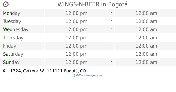
WINGS-N-BEER
-26, Carrera 58 #132A, Bogotá
Bar
read more
463 m
Mundo Cervecero
Calle 134 # 55A-30 local 321, Bogotá
Bar
read more
474 m
La Doña Mexicana
Calle 138 #53, Bogotá
Bar
read more
489 m
La Doña Mexicana
Calle 138 #55 - 53, Bogotá
Bar
read more
492 m
Bar Angus
Avenida Carrera 58, Bogotá
Bar
read more
494 m
BBC colina campestre
Suba, Bogotá
Bar
read more
499 m
BBC Bogotá Beer Company
Suba, Bogotá
Bar
read more
523 m
Matusalem Bar
Carrera 56a #137b-60, Bogotá
Bar
read more
525 m
Palos de Moguer
#137a- a 137a-, Avenida Boyacá #128b98, Bogotá
Bar
read more
541 m
La Recoletta
Colombia
Bar
read more
647 m
The Pantry
Calle 131 #58B-67, Bogotá
Bar
read more
656 m
London Pub Karaoke Bar
Carrera 59 ##131-59, Bogotá
Bar
read more
736 m
La Jungla Bar 15
b, Boyacá #137-75, Bogotá
Bar
read more
749 m
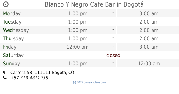
Blanco Y Negro Cafe Bar
Local. 291, Carrera 58, Bogotá
Bar
read more
749 m
Sabina Pub
L2-75 Plaza Aventura, Calle 130 #58-20, Bogotá
Bar
read more
822 m
Felix
Calle 129c #57a-04, Bogotá
Bar
read more
827 m
Fútbol y Café
Calle 130 #5885, Bogotá
Bar
read more
843 m
BEER
a 59b-99,, Calle 130a #59b1, Bogotá
Bar
read more
868 m
Bar D.jabu
entre calle 130 y 129b, Carrera 59 #129b-76, Bogotá
Bar
read more
1.01 km
Tabacófilos
C, Calle 130, Bogotá
Bar
read more
1.02 km
990 Craft Beer
Calle 129 # 58c - 55
Bar
read more
1.17 km
Cervecería Moonshine
Calle 134a #50-30, Bogotá
Bar
read more
📑
all categories
Accounting
Administrative area level 1
Administrative area level 2
Airport
Amusement park
Aquarium
Art gallery
Atm
Bakery
Bank
Bar
Beauty salon
Bicycle store
Book store
Bowling alley
Bus station
Cafe
Campground
Car dealer
Car rental
Car repair
Car wash
Casino
Cemetery
Church
City hall
Clothing store
Colloquial area
Convenience store
Country
Courthouse
Dentist
Department store
Doctor
Electrician
Electronics store
Embassy
Establishment
Finance
Fire station
Florist
Food
Funeral home
Furniture store
Gas station
General contractor
Grocery or supermarket
Gym
Hair care
Hardware store
Health
Hindu Temple
Home goods store
Hospital
Insurance agency
Intersection
Jewelry store
Laundry
Lawyer
Library
Light rail station
Liquor store
Local government office
Locality
Locksmith
Lodging
Meal delivery
Meal takeaway
Mosque
Movie rental
Movie theater
Moving company
Museum
Natural feature
Neighborhood
Night club
Painter
Park
Parking
Pet store
Pharmacy
Physiotherapist
Place of worship
Plumber
Point of interest
Police
Political
Post office
Premise
Real estate agency
Restaurant
Roofing contractor
Route
Rv park, camping
School
Shoe store
Shopping mall
Spa
Stadium
Storage
Store
Subpremise
Subway station
Supermarket
Synagogue
Taxi stand
Train station
Transit station
Travel agency
University
Veterinary care
Zoo
administrative area level 3
sublocality level 1
↑