Food nearby Tienda Sary
Coronavirus disease (COVID-19) Situation
confirmed cases
6400173
deaths
143200
Colombia
Food nearby Tienda Sary
Tienda Sary
128 C, Carrera 56b, 111111, Bogotá, CO Colombia
contacts phone
:
+57
Latitude:
4.716624
, Longitude:
-74.065764
larger map & directions
read more
nearest Food
380 m
Huevos Santa Reyes
Carrera 58 #129B-22, Bogotá
Food
read more
446 m
PatArepa
Calle 130 #58-20, Bogotá
Food
read more
552 m
LA CASA DE LA PAELLA
Carrera 58 # 128BIS-61, Bogotá
Food
read more
558 m
El Guarnis
Carrera 58 #131-76, Bogotá
Food
read more
567 m
Obleas DANY
Calle 127 #60-75, Bogotá
Food
read more
578 m
Doña Leche
07, Carrera 58 #128, Bogotá
Food
read more
663 m
La Platanera
Bogotá
Food
read more
688 m
Jaime Gourmet Ceviche y Sushi
Carrera 58 #127-59, Bogotá
Food
read more
718 m
La Granja
Carrera 59 #130-36, Bogotá
Food
read more
741 m
Distriaromas de Colombia
Tv. 59B Nº 128-46, Bogotá
Food
read more
763 m
El Galeon
54, Carrera 59 #130 A, Bogotá
Food
read more
771 m
el langostino
Calle 134 #55-30, Bogotá
Food
read more
781 m
Spoleto
Calle 126 #52-96, Bogotá
Food
read more
785 m
Plasticos Y Desechables
13, Calle 129 #52, Bogotá
Food
read more
794 m
Distribuidora De Pollos Karen
Carrera 59 #131-36, Bogotá
Food
read more
816 m
Steak Station
Calle 134 # 55-30 centro comercial san rafael, Bogotá
Food
read more
841 m
Hidraulicos Solano
Avenida Suba #1Sur, Bogotá
Food
read more
865 m
BATIMIX
Suba, Bogotá
Food
read more
879 m
MATILKA
Carrera 52 #127D-26, Bogotá
Food
read more
883 m
Calentao express
Carrera 58 #127-59, Bogotá
Food
read more
916 m
Cafe Export Colombia
Calle 127 B Bis 51A-68, Bloque 1 Apto 524 Niza IX, Bogota
Food
read more
984 m
Deli Repostería
Transversal 60 # 127 - 45, C.C. Niza, Local 28, Bogotá
Food
read more
1.074 km
Jungla Kumba
Carrera 59d #131-45, Bogotá
Food
read more
1.163 km
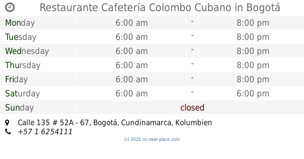
Restaurante Cafetería Colombo Cubano
Calle 135 # 52A - 67, Bogotá
Food
read more
1.187 km
Café Restaurante Muffo's
0 Av. # D-85, Calle 127 #7170, Bogotá
Food
read more
📑
all categories
Accounting
Administrative area level 1
Administrative area level 2
Airport
Amusement park
Aquarium
Art gallery
Atm
Bakery
Bank
Bar
Beauty salon
Bicycle store
Book store
Bowling alley
Bus station
Cafe
Campground
Car dealer
Car rental
Car repair
Car wash
Casino
Cemetery
Church
City hall
Clothing store
Colloquial area
Convenience store
Country
Courthouse
Dentist
Department store
Doctor
Electrician
Electronics store
Embassy
Establishment
Finance
Fire station
Florist
Food
Funeral home
Furniture store
Gas station
General contractor
Grocery or supermarket
Gym
Hair care
Hardware store
Health
Hindu Temple
Home goods store
Hospital
Insurance agency
Intersection
Jewelry store
Laundry
Lawyer
Library
Light rail station
Liquor store
Local government office
Locality
Locksmith
Lodging
Meal delivery
Meal takeaway
Mosque
Movie rental
Movie theater
Moving company
Museum
Natural feature
Neighborhood
Night club
Painter
Park
Parking
Pet store
Pharmacy
Physiotherapist
Place of worship
Plumber
Point of interest
Police
Political
Post office
Premise
Real estate agency
Restaurant
Roofing contractor
Route
Rv park, camping
School
Shoe store
Shopping mall
Spa
Stadium
Storage
Store
Subpremise
Subway station
Supermarket
Synagogue
Taxi stand
Train station
Transit station
Travel agency
University
Veterinary care
Zoo
administrative area level 3
sublocality level 1
↑