Pharmacy nearby Droguería farmasanitas
Colombia
Pharmacy nearby Droguería farmasanitas
Droguería farmasanitas
Carrera 13 #54-84, Bogotá Kolumbia
contacts phone
:
+57
Latitude:
4.6418941
, Longitude:
-74.0647789
read more
nearest Pharmacy
228 m
la rebaja plus MINIMARKET DROGUERIA
Calle 57 #09-75, Bogotá
Pharmacy
read more
526 m
DROGAS LA REBAJA
Calle 60 #9-09, Bogotá
Pharmacy
read more
623 m
Drogueria Séptima
Carrera 7 #60-73, Bogotá
Pharmacy
read more
644 m
Superfharma Marly 50
Bogotá
Pharmacy
read more
644 m
Droguería Colsubsidio Marly
Carrera 8 #49-5, Bogotá
Pharmacy
read more
645 m
Drogas P y Arango
Calle 61 #9-28, Bogotá
Pharmacy
read more
646 m
Droguerías
Bogotá
Pharmacy
read more
648 m
Droguería Colsubsidio
02, Calle 49 #08, Bogotá
Pharmacy
read more
650 m
Drogas Glorimar Del Madrigal
Calle 61, Bogotá
Pharmacy
read more
650 m
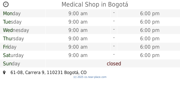
Medical Shop
Carrera 9 #61-08, Bogotá
Pharmacy
read more
678 m
Punto de Dispensación - Framar S y Cia Ltda
68, Local 101, Carrera 7 #48 A, Bogotá
Pharmacy
read more
750 m
Tienda Esotérica Caminos De Esperanza
Bogotá
Pharmacy
read more
831 m
Jazmines Asahares Y Permuferia No 2
Colombia
Pharmacy
read more
861 m
Drogas Super Andina
Caracas #47 - 04, Bogotá
Pharmacy
read more
924 m
Droguería Y Perfumería Séptima 4
Bogotá
Pharmacy
read more
925 m
BOGOTA 1 -POSITIVA
4°38'40. 74°04'21., Carrera 7 #5"N
Pharmacy
read more
942 m
Farmacia London Homeopatía
Avenida Calle 63 #16a-17, Bogotá
Pharmacy
read more
961 m
Pharmacity Chapinero
Colombia
Pharmacy
read more
969 m
Drogueria Séptima
Carrera 7 #64-26, Bogotá
Pharmacy
read more
1.03 km
Droguería Fagem
Calle 65 #6-15, Bogotá
Pharmacy
read more
1.031 km
La Economía
Calle 65 #6-15, Bogotá
Pharmacy
read more
1.141 km
Drogueria Cruz Verde Palermo
Carrera 22 #45c-44, Bogotá
Pharmacy
read more
1.243 km
Droguería Francoop R.P
Carrera 4a #66-69, Bogotá
Pharmacy
read more
1.262 km
Drogueria Séptima
Carrera 7 #67-28, Bogotá
Pharmacy
read more
1.272 km
Droguería Colfarma
Carrera 4a #66-62, Bogotá
Pharmacy
read more
📑
all categories
Accounting
Administrative area level 1
Administrative area level 2
Airport
Amusement park
Aquarium
Art gallery
Atm
Bakery
Bank
Bar
Beauty salon
Bicycle store
Book store
Bowling alley
Bus station
Cafe
Campground
Car dealer
Car rental
Car repair
Car wash
Casino
Cemetery
Church
City hall
Clothing store
Colloquial area
Convenience store
Country
Courthouse
Dentist
Department store
Doctor
Electrician
Electronics store
Embassy
Establishment
Finance
Fire station
Florist
Food
Funeral home
Furniture store
Gas station
General contractor
Grocery or supermarket
Gym
Hair care
Hardware store
Health
Hindu Temple
Home goods store
Hospital
Insurance agency
Intersection
Jewelry store
Laundry
Lawyer
Library
Light rail station
Liquor store
Local government office
Locality
Locksmith
Lodging
Meal delivery
Meal takeaway
Mosque
Movie rental
Movie theater
Moving company
Museum
Natural feature
Neighborhood
Night club
Painter
Park
Parking
Pet store
Pharmacy
Physiotherapist
Place of worship
Plumber
Point of interest
Police
Political
Post office
Premise
Real estate agency
Restaurant
Roofing contractor
Route
Rv park, camping
School
Shoe store
Shopping mall
Spa
Stadium
Storage
Store
Subpremise
Subway station
Supermarket
Synagogue
Taxi stand
Train station
Transit station
Travel agency
University
Veterinary care
Zoo
administrative area level 3
sublocality level 1
↑