Bakery nearby Ponqué Sandra
Colombia
Bakery nearby Ponqué Sandra
Ponqué Sandra
Carrera 16 #13-73, Duitama Colombia
contacts phone
:
+57
Latitude:
5.8265538
, Longitude:
-73.0348134
read more
nearest Bakery
155 m
Pasteleria Deivys
Carrera 18 #34, Duitama
Bakery
read more
193 m
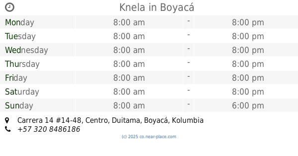
Knela
Carrera 14 #14-48, Centro, Duitama
Bakery
read more
201 m
Panaderia Pan Rey
Calle 12 No.17-51, Centro, Duitama
Bakery
read more
226 m
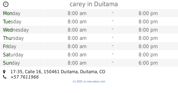
carey
Calle 16 #17-35, Duitama, Duitama
Bakery
read more
238 m
Inti Pan
Carrera 15 #11-16, EL Carmen, Duitama
Bakery
read more
258 m
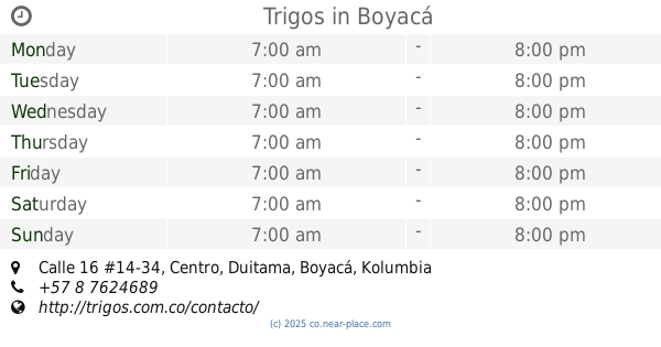
Trigos
Calle 16 #14-34, Centro, Duitama
Bakery
read more
275 m
Trigos
Calle 15 #18A-31, Centro, Duitama
Bakery
read more
383 m
Ponque Sandra
Carrera 14 No. 1757, Duitama
Bakery
read more
419 m
Pan'tojarse
Calle 15 No. 11A 39, Centro, Duitama
Bakery
read more
490 m
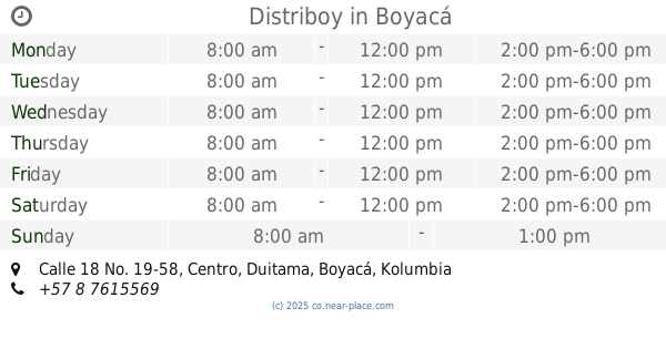
Distriboy
Calle 18 No. 19-58, Centro, Duitama
Bakery
read more
492 m
Pan del Campo
Calle 18 No. 13-05, Duitama
Bakery
read more
659 m
La Esquina del Croissant
Carrera 9a No.13111, Duitama
Bakery
read more
659 m
Croissant Corner
Carrera 9a No.13111, Duitama
Bakery
read more
708 m
Pan Fino
Duitama
Bakery
read more
785 m
Gustytortas
Carrera 18 N.20 -177, San Vicente, Duitama
Bakery
read more
862 m
Pan Del Oeste
Carrera 8 No. 16-5, Integrado, Duitama
Bakery
read more
871 m
Ricopan.com
Calle 22 #12-28, Solano, Duitama
Bakery
read more
957 m
Panaderia & Pasteleria Tundama
Carrera 23 #2-78, Duitama
Bakery
read more
993 m
Mecaticos
Carrera 22 #22-27, San Juan Bosco, Duitama
Bakery
read more
1.165 km
Pasteleria MANOLOS
Calle 17A #5-132, Duitama
Bakery
read more
1.257 km
Ponque Nevada
Transversal 30 #10-43, Duitama
Bakery
read more
1.627 km
Panaderìa Marletty
Calle 9, Duitama
Bakery
read more
1.805 km
Mantecaña
Carrera 35 #10-10, La Esperanza, Duitama
Bakery
read more
16.555 km
Fresko Pan
Calle 11 #16-26, Santa Ines, Sogamoso
Bakery
read more
17.121 km
El Buen Sabor De La U
Calle 3 Sur#15-07, Universitario, Sogamoso
Bakery
read more
📑
all categories
Accounting
Administrative area level 1
Administrative area level 2
Airport
Amusement park
Aquarium
Art gallery
Atm
Bakery
Bank
Bar
Beauty salon
Bicycle store
Book store
Bowling alley
Bus station
Cafe
Campground
Car dealer
Car rental
Car repair
Car wash
Casino
Cemetery
Church
City hall
Clothing store
Colloquial area
Convenience store
Country
Courthouse
Dentist
Department store
Doctor
Electrician
Electronics store
Embassy
Establishment
Finance
Fire station
Florist
Food
Funeral home
Furniture store
Gas station
General contractor
Grocery or supermarket
Gym
Hair care
Hardware store
Health
Hindu Temple
Home goods store
Hospital
Insurance agency
Intersection
Jewelry store
Laundry
Lawyer
Library
Light rail station
Liquor store
Local government office
Locality
Locksmith
Lodging
Meal delivery
Meal takeaway
Mosque
Movie rental
Movie theater
Moving company
Museum
Natural feature
Neighborhood
Night club
Painter
Park
Parking
Pet store
Pharmacy
Physiotherapist
Place of worship
Plumber
Point of interest
Police
Political
Post office
Premise
Real estate agency
Restaurant
Roofing contractor
Route
Rv park, camping
School
Shoe store
Shopping mall
Spa
Stadium
Storage
Store
Subpremise
Subway station
Supermarket
Synagogue
Taxi stand
Train station
Transit station
Travel agency
University
Veterinary care
Zoo
administrative area level 3
sublocality level 1
↑