Cafe nearby Bosque Calderon Tejada
Colombia
Cafe nearby Bosque Calderon Tejada
Bosque Calderon Tejada
# a 61a-59,, Transversal 4b Este #611, Bogotá Kolumbia
contacts phone
:
+57
Latitude:
4.6419415
, Longitude:
-74.0532775
read more
nearest Cafe
639 m
Chiquerito recargado
Avenida Circunvalar #57-09, Bogotá
Cafe
read more
725 m
Super Tienda BLANCO Y NEGRO
Carrera 3a #56 -41, Bogotá
Cafe
read more
815 m
Amor Perfecto Café
Carrera 4 #66-46, Bogotá
Cafe
read more
815 m
Amor Perfecto
Carrera 4 #66-46, Bogotá
Cafe
read more
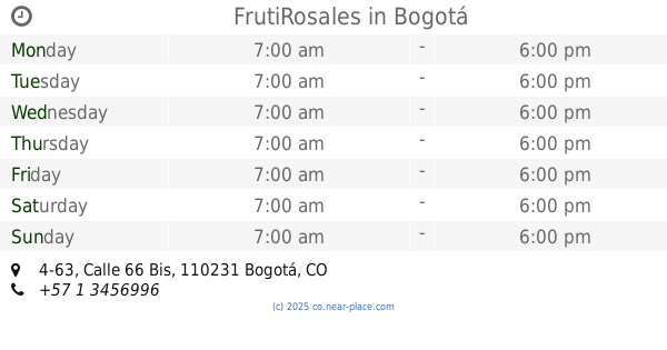
834 m
FrutiRosales
Calle 66 Bis #4-63, Bogotá
Cafe
read more
856 m
ORSO HELADERÍA Zona G
Calle 66 #4a -08, Bogotá
Cafe
read more
929 m
Juan Valdez Café
Carrera 7 #61-52, Bogotá
Cafe
read more
940 m
Juan Valdéz Ak7
Carrera 7 #61-52, Bogotá
Cafe
read more
963 m
Telmex
Carrera 7 #63-44, Bogotá
Cafe
read more
976 m
Nick's
Carrera 4 #69-23, Bogotá
Cafe
read more
1.002 km
La Mago
Calle 55 ##6- 31, Bogotá
Cafe
read more
1.012 km
TU CAFE Vending
a 6-59,, Calle 65 #6-1, Bogotá
Cafe
read more
1.064 km
aromatica natural doña lucy
Bogotá
Cafe
read more
1.069 km
Caf y Bar Castro
Calle 62 #7-62, Bogotá
Cafe
read more
1.088 km
SELVA NEGRA PASTELERIA CAFÉ
#61-97, Carrera 9, Bogotá
Cafe
read more
1.091 km
La Tortáta
Calle 66 #7-18 Local 1, Bogota
Cafe
read more
1.092 km
Cafe Sirope Koc- t- les
Calle 60 #9-60, Bogotá
Cafe
read more
1.095 km
Cafe Bar Sirope
Calle 60 #9-08, Bogotá
Cafe
read more
1.138 km
Village Café
Carrera 8 #64-29, Bogotá
Cafe
read more
1.147 km
ok tienda de convencía
Calle 67 #07-35, Bogotá
Cafe
read more
1.153 km
Duocafé
Calle 64 #8-28, Bogotá
Cafe
read more
1.203 km
Pan Lab Fabrica De Masas
Carrera 9 ##64-49, Bogotá
Cafe
read more
1.205 km
Milk House Café
Calle 67 #Cl. 67 #7 35
Cafe
read more
1.215 km
Aroma y buen gusto
Carrera 9a #62-61, Bogotá
Cafe
read more
1.366 km
Panaderia Y Pasteleria Nutibara
Bogotá
Cafe
read more
📑
all categories
Accounting
Administrative area level 1
Administrative area level 2
Airport
Amusement park
Aquarium
Art gallery
Atm
Bakery
Bank
Bar
Beauty salon
Bicycle store
Book store
Bowling alley
Bus station
Cafe
Campground
Car dealer
Car rental
Car repair
Car wash
Casino
Cemetery
Church
City hall
Clothing store
Colloquial area
Convenience store
Country
Courthouse
Dentist
Department store
Doctor
Electrician
Electronics store
Embassy
Establishment
Finance
Fire station
Florist
Food
Funeral home
Furniture store
Gas station
General contractor
Grocery or supermarket
Gym
Hair care
Hardware store
Health
Hindu Temple
Home goods store
Hospital
Insurance agency
Intersection
Jewelry store
Laundry
Lawyer
Library
Light rail station
Liquor store
Local government office
Locality
Locksmith
Lodging
Meal delivery
Meal takeaway
Mosque
Movie rental
Movie theater
Moving company
Museum
Natural feature
Neighborhood
Night club
Painter
Park
Parking
Pet store
Pharmacy
Physiotherapist
Place of worship
Plumber
Point of interest
Police
Political
Post office
Premise
Real estate agency
Restaurant
Roofing contractor
Route
Rv park, camping
School
Shoe store
Shopping mall
Spa
Stadium
Storage
Store
Subpremise
Subway station
Supermarket
Synagogue
Taxi stand
Train station
Transit station
Travel agency
University
Veterinary care
Zoo
administrative area level 3
sublocality level 1
↑