Cemetery nearby Jewish Cemetery
Colombia
Cemetery nearby Jewish Cemetery
Jewish Cemetery
Bogotá Colombia
contacts phone
:
+57
Latitude:
4.5872959
, Longitude:
-74.1226369
read more
nearest Cemetery
64 m
Cementerio Judio Barrio Ingls
Calle 39 Sur #31-53, Bogotá
Cemetery
read more
94 m
Cementerio
Tv. 23 #38b Sur-64 a 38b Sur-86, Bogotá
Cemetery
read more
559 m
Cementrio Del Sur
Bogotá
Cemetery
read more
5.596 km
Cementerio El Apogeo
Carrera 76 #39 Sur27, Bogotá
Cemetery
read more
5.959 km
Esperanza 2 # 915
#75f- a 75f-, Calle 57l Sur #75f22, Bogotá
Cemetery
read more
6.167 km
Tumba de Julio Garavito
a 24b-98, Carrera 19 #24b2, Bogotá
Cemetery
read more
6.184 km
Cementerio Bóvedas
Carrera 19 #2436, Bogotá
Cemetery
read more
6.199 km
Cementerio Central
Carrera 20 #3780, Bogotá
Cemetery
read more
6.235 km
Cementerio Británico
Transversal 17, Bogotá
Cemetery
read more
6.291 km
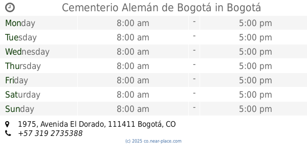
Cementerio Alemán de Bogotá
Avenida El Dorado #1975, Bogotá
Cemetery
read more
7.579 km
Bosa Piedmont Cemetery
Calle 68a Sur #79-80, Bogotá
Cemetery
read more
9.939 km
Chapinero Cemetery
Calle 68 #88, Bogotá
Cemetery
read more
9.939 km
Cementerio de Chapinero
Calle 68 #88, Bogotá
Cemetery
read more
10.017 km
North Cemetery
Calle 70, Bogotá
Cemetery
read more
10.245 km
funeravet
Calle 70a #53-41, Bogotá, Bogotá
Cemetery
read more
10.245 km
funeravet
Calle 70a #53-41
Cemetery
read more
10.245 km
Funeraria para mascotas
Calle 70a #53-41, Bogotá, Bogotá
Cemetery
read more
11.013 km
Jardín Cementerio Fontibón
Calle 23d #106-36, Bogotá
Cemetery
read more
11.013 km
Garden Cemetery Fontibon
Calle 23d #106-36, Bogotá
Cemetery
read more
11.098 km
Soacha municipal cemetery
Bochica, Soacha
Cemetery
read more
11.098 km
Cementerio municipal de Soacha
Bochica, Soacha
Cemetery
read more
14.2 km
Cementerio Campos De Cristo
Autopista Sur #Kilómetro 14, Soacha
Cemetery
read more
14.491 km
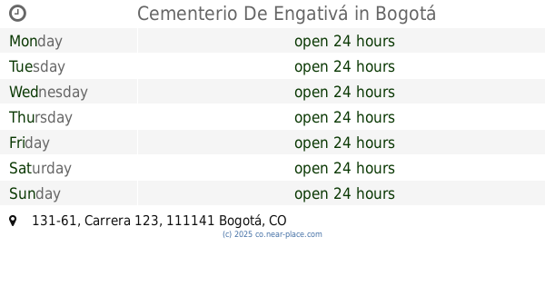
Cementerio De Engativá
Carrera 123 #131-61, Bogotá
Cemetery
read more
15.958 km
Cementerio de Usaquén
Bogotá
Cemetery
read more
15.966 km
Cementerio de La Paz
Carrera 6 #120a22, Bogotá
Cemetery
read more
📑
all categories
Accounting
Administrative area level 1
Administrative area level 2
Airport
Amusement park
Aquarium
Art gallery
Atm
Bakery
Bank
Bar
Beauty salon
Bicycle store
Book store
Bowling alley
Bus station
Cafe
Campground
Car dealer
Car rental
Car repair
Car wash
Casino
Cemetery
Church
City hall
Clothing store
Colloquial area
Convenience store
Country
Courthouse
Dentist
Department store
Doctor
Electrician
Electronics store
Embassy
Establishment
Finance
Fire station
Florist
Food
Funeral home
Furniture store
Gas station
General contractor
Grocery or supermarket
Gym
Hair care
Hardware store
Health
Hindu Temple
Home goods store
Hospital
Insurance agency
Intersection
Jewelry store
Laundry
Lawyer
Library
Light rail station
Liquor store
Local government office
Locality
Locksmith
Lodging
Meal delivery
Meal takeaway
Mosque
Movie rental
Movie theater
Moving company
Museum
Natural feature
Neighborhood
Night club
Painter
Park
Parking
Pet store
Pharmacy
Physiotherapist
Place of worship
Plumber
Point of interest
Police
Political
Post office
Premise
Real estate agency
Restaurant
Roofing contractor
Route
Rv park, camping
School
Shoe store
Shopping mall
Spa
Stadium
Storage
Store
Subpremise
Subway station
Supermarket
Synagogue
Taxi stand
Train station
Transit station
Travel agency
University
Veterinary care
Zoo
administrative area level 3
sublocality level 1
↑