Doctor nearby Drogas la rebaja
Colombia
Doctor nearby Drogas la rebaja
Drogas la rebaja
5b87, Calle 21, 410010, Neiva, Neiva, CO Colombia
contacts phone
:
+57
Latitude:
2.9378268
, Longitude:
-75.2894541
larger map & directions
read more
nearest Doctor
140 m
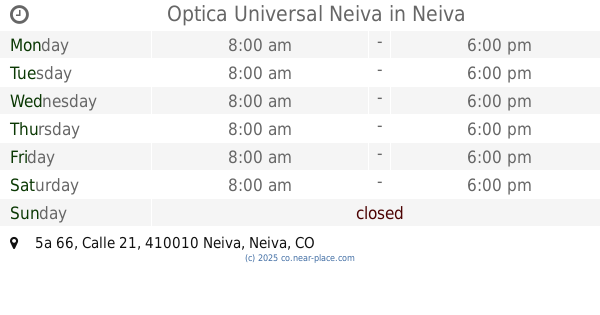
Optica Universal Neiva
Calle 21 #5a 66, Neiva
Doctor
read more
191 m
Óptica Protegemos
Neiva
Doctor
read more
198 m
Cardio Center
Calle 18a #750, Neiva
Doctor
read more
234 m
MI IPS QUIRINAL
Calle 18 #7-102, Neiva
Doctor
read more
244 m
Edificio de consultorios medicos LAS CEIBAS Md.
esquina, Carrera 7, Bogotá
Doctor
read more
252 m
Sede EMCOSALUD Famisalud
a 6-105, Calle 17a #6-1, Neiva
Doctor
read more
279 m
Fundación Sigamos ADELANTE
Calle 17a #7-73, Neiva, Neiva
Doctor
read more
281 m
MI IPS POMAR
Calle 17a #5a-120, Neiva
Doctor
read more
289 m
Home Nutrition
Calle 17A #5A-82, Centro, Neiva
Doctor
read more
317 m
MI IPS LOS ROBLES
Carrera 5a Bis #17-56, Neiva
Doctor
read more
360 m
Odontosalud-P
# a 16a-55,, Carrera 6 #161, Neiva
Doctor
read more
387 m
Sanar - Clinica de heridas
a 16-87, Carrera 6a #16-1, Neiva
Doctor
read more
415 m
Imagenes Orales LTDA
Calle 16 #6-40, Neiva
Doctor
read more
618 m
SOI... Clinica Dental
a 14-98, Carrera 5 #14-2, Neiva
Doctor
read more
702 m
MEDICINA LEGAL
#6-2 a, Calle 13 #676, Neiva
Doctor
read more
730 m
Coomeva
Calle 13 #5- 44, Neiva
Doctor
read more
779 m
Edicifio El Nogal
Calle 12 #5-37, Neiva
Doctor
read more
793 m
Rehabilitamos IPS
Calle 12 #100, Neiva
Doctor
read more
849 m
Dr. Miguel Fernando Piñeres Hernández
Calle 12 #4-58, Neiva, Neiva
Doctor
read more
853 m
League Against Cancer
Avenida La Toma 1G-59, Neiva
Doctor
read more
901 m
Dental M&M
Carrera 4 #1159, Neiva
Doctor
read more
946 m
Edificio Casa Real
Carrera 5 #10-49, Neiva
Doctor
read more
967 m
ONCORED COLOMBIA
AVENIDA LA TOMA 14-13, Local 101, Neiva
Doctor
read more
987 m
Clinica Dental Dr.A
Calle 10 #612, Neiva
Doctor
read more
1.062 km
Consultorio Médico
Calle 9 #8-70, Altico
Doctor
read more
📑
all categories
Accounting
Administrative area level 1
Administrative area level 2
Airport
Amusement park
Aquarium
Art gallery
Atm
Bakery
Bank
Bar
Beauty salon
Bicycle store
Book store
Bowling alley
Bus station
Cafe
Campground
Car dealer
Car rental
Car repair
Car wash
Casino
Cemetery
Church
City hall
Clothing store
Colloquial area
Convenience store
Country
Courthouse
Dentist
Department store
Doctor
Electrician
Electronics store
Embassy
Establishment
Finance
Fire station
Florist
Food
Funeral home
Furniture store
Gas station
General contractor
Grocery or supermarket
Gym
Hair care
Hardware store
Health
Hindu Temple
Home goods store
Hospital
Insurance agency
Intersection
Jewelry store
Laundry
Lawyer
Library
Light rail station
Liquor store
Local government office
Locality
Locksmith
Lodging
Meal delivery
Meal takeaway
Mosque
Movie rental
Movie theater
Moving company
Museum
Natural feature
Neighborhood
Night club
Painter
Park
Parking
Pet store
Pharmacy
Physiotherapist
Place of worship
Plumber
Point of interest
Police
Political
Post office
Premise
Real estate agency
Restaurant
Roofing contractor
Route
Rv park, camping
School
Shoe store
Shopping mall
Spa
Stadium
Storage
Store
Subpremise
Subway station
Supermarket
Synagogue
Taxi stand
Train station
Transit station
Travel agency
University
Veterinary care
Zoo
administrative area level 3
sublocality level 1
↑