Park nearby Parque
Colombia
Park nearby Parque
Parque
Plan 554 Mz-101 lote 8, Cartagena Kolumbien
contacts phone
:
+57
Latitude:
10.3850391
, Longitude:
-75.4791611
read more
nearest Park
Parque
Plan 554 Mz-101 lote 8
Park
read more
128 m
Parque
Mz. 37, Cartagena
Park
read more
133 m
Parque
Plan 554
Park
read more
211 m
Parque Bohio
Carrera 78 #Mz 44, Cartagena
Park
read more
228 m
Parque
# Bis-56, Calle 21
Park
read more
330 m
Parque
Plan 50, Mz. 17
Park
read more
365 m
Plan 332A Park
Carrera 78, Cartagena
Park
read more
543 m
Santa monica Main Park
esquina con Carrera 3, Carrera 79, Cartagena
Park
read more
578 m
Parque Bohio
Mz V a una Cuadra de Calle 20, Calle 20, Cartagena
Park
read more
679 m
Alameda la Victoria Park
Carrera 80, Cartagena
Park
read more
691 m
Parque la mano de Dios
Carrera 71 esquina Calle 19, Cartagena
Park
read more
724 m
Parque de la 19
Calle 19, Cartagena
Park
read more
747 m
Parque el Divino Niño
Carrera 68 #Mz 4
Park
read more
754 m
Parque de la Urbanización Villa Alejandra
#81- a, Calle 22 #81125, Cartagena
Park
read more
783 m
Mallorca Park
a 31c-79, Carrera 80a #31c-3, Cartagena
Park
read more
795 m
Parque
Carrera 80E #22 C, Cartagena
Park
read more
832 m
las Bongas Park
Carrera 67B #Mz8, Cartagena
Park
read more
832 m
Parque las Bongas
Carrera 67B #Mz8, Cartagena
Park
read more
876 m
Parque de la 68
Carrera 68, Cartagena
Park
read more
891 m
Parque Santa lucia
#31a- a, Carrera 69 #31a46, Cartagena
Park
read more
893 m
Parque Virgen de la Candelaria
Mz. 5 3ra. Etapa, Cartagena
Park
read more
908 m
Parque de Barú
10°23'27. 75°28'24., Calle 3 #14, Puerto Rondón
Park
read more
957 m
Parque de Los Abetos
#31f- a, Carrera 80a #31f65, Cartagena
Park
read more
997 m
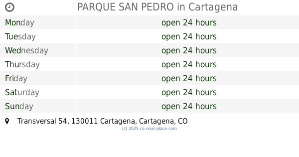
PARQUE SAN PEDRO
carrera 30, Transversal 54, Cartagena
Park
read more
1.122 km
PARQUE INFANTIL BLAS DE LEZO
Parque Blas de Lezo, Transversal 54, Cartagena
Park
read more
📑
all categories
Accounting
Administrative area level 1
Administrative area level 2
Airport
Amusement park
Aquarium
Art gallery
Atm
Bakery
Bank
Bar
Beauty salon
Bicycle store
Book store
Bowling alley
Bus station
Cafe
Campground
Car dealer
Car rental
Car repair
Car wash
Casino
Cemetery
Church
City hall
Clothing store
Colloquial area
Convenience store
Country
Courthouse
Dentist
Department store
Doctor
Electrician
Electronics store
Embassy
Establishment
Finance
Fire station
Florist
Food
Funeral home
Furniture store
Gas station
General contractor
Grocery or supermarket
Gym
Hair care
Hardware store
Health
Hindu Temple
Home goods store
Hospital
Insurance agency
Intersection
Jewelry store
Laundry
Lawyer
Library
Light rail station
Liquor store
Local government office
Locality
Locksmith
Lodging
Meal delivery
Meal takeaway
Mosque
Movie rental
Movie theater
Moving company
Museum
Natural feature
Neighborhood
Night club
Painter
Park
Parking
Pet store
Pharmacy
Physiotherapist
Place of worship
Plumber
Point of interest
Police
Political
Post office
Premise
Real estate agency
Restaurant
Roofing contractor
Route
Rv park, camping
School
Shoe store
Shopping mall
Spa
Stadium
Storage
Store
Subpremise
Subway station
Supermarket
Synagogue
Taxi stand
Train station
Transit station
Travel agency
University
Veterinary care
Zoo
administrative area level 3
sublocality level 1
↑