Park nearby PARUQUE 2 LOS CARACOLES
Colombia
Park nearby PARUQUE 2 LOS CARACOLES
PARUQUE 2 LOS CARACOLES
Transversal 60, 130011, Cartagena, Cartagena, CO Colombia
contacts phone
:
+57
Latitude:
10.3886562
, Longitude:
-75.4915902
larger map & directions
read more
nearest Park
60 m
ROMPOI LOS CARACOLES
Cartagena
Park
read more
78 m
ZONA VERDE DE LA 34
Cartagena
Park
read more
92 m
parque de la 36
# a 62-207, Calle 22B #623, Cartagena
Park
read more
135 m
PARQUE VIRGEN DEL CARMEN CARACOLES Entrada
Cartagena
Park
read more
370 m
ADAGUIZA CALDERÓN Park
Transversal 58, Calle 21A #21-07, Cartagena
Park
read more
370 m
PARQUE ADAGUIZA CALDERÓN
Transversal 58, Calle 21A #21-07, Cartagena
Park
read more
436 m
SURTIGAS Park
Transversal 57D, Calle 21 #21, Cartagena
Park
read more
440 m
PARQUE ALMIRANTE COLÓN TERCERA ETAPA
37, Calle 21 #55B
Park
read more
482 m
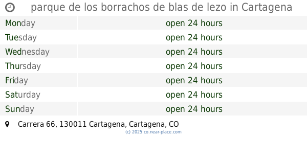
parque de los borrachos de blas de lezo
Carrera 66, Cartagena
Park
read more
576 m
PARQUE INFANTIL BLAS DE LEZO
Parque Blas de Lezo, Transversal 54, Cartagena
Park
read more
583 m
la troncal Park
Diagonal 45, Cartagena
Park
read more
656 m
PARQUE TACARIGUA
Con diagonal 62, Calle 30, Cartagena
Park
read more
779 m
I Etapa
Almirante Colón
Park
read more
798 m
Parque las Bongas
Carrera 67B #Mz8, Cartagena
Park
read more
798 m
las Bongas Park
Carrera 67B #Mz8, Cartagena
Park
read more
815 m
Parque Virgen de la Candelaria
Mz. 5 3ra. Etapa, Cartagena
Park
read more
849 m
Parque de la 68
Carrera 68, Cartagena
Park
read more
881 m
Parque el Divino Niño
Carrera 68 #Mz 4
Park
read more
891 m
Villa Leon
La Fragata
Park
read more
965 m
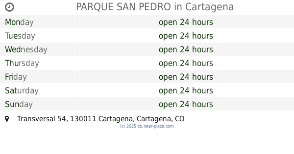
PARQUE SAN PEDRO
carrera 30, Transversal 54, Cartagena
Park
read more
1.094 km
Parque de la 19
Calle 19, Cartagena
Park
read more
1.124 km
Parque la mano de Dios
Carrera 71 esquina Calle 19
Park
read more
1.124 km
Parque la mano de Dios
Carrera 71 esquina Calle 19, Cartagena
Park
read more
1.185 km
Parque Los Calamares
Mz. 41, Cartagena
Park
read more
1.186 km
PARQUE CALAMARES
Mz. 33., Cartagena
Park
read more
📑
all categories
Accounting
Administrative area level 1
Administrative area level 2
Airport
Amusement park
Aquarium
Art gallery
Atm
Bakery
Bank
Bar
Beauty salon
Bicycle store
Book store
Bowling alley
Bus station
Cafe
Campground
Car dealer
Car rental
Car repair
Car wash
Casino
Cemetery
Church
City hall
Clothing store
Colloquial area
Convenience store
Country
Courthouse
Dentist
Department store
Doctor
Electrician
Electronics store
Embassy
Establishment
Finance
Fire station
Florist
Food
Funeral home
Furniture store
Gas station
General contractor
Grocery or supermarket
Gym
Hair care
Hardware store
Health
Hindu Temple
Home goods store
Hospital
Insurance agency
Intersection
Jewelry store
Laundry
Lawyer
Library
Light rail station
Liquor store
Local government office
Locality
Locksmith
Lodging
Meal delivery
Meal takeaway
Mosque
Movie rental
Movie theater
Moving company
Museum
Natural feature
Neighborhood
Night club
Painter
Park
Parking
Pet store
Pharmacy
Physiotherapist
Place of worship
Plumber
Point of interest
Police
Political
Post office
Premise
Real estate agency
Restaurant
Roofing contractor
Route
Rv park, camping
School
Shoe store
Shopping mall
Spa
Stadium
Storage
Store
Subpremise
Subway station
Supermarket
Synagogue
Taxi stand
Train station
Transit station
Travel agency
University
Veterinary care
Zoo
administrative area level 3
sublocality level 1
↑