Pharmacy nearby Septifarma
Colombia
Pharmacy nearby Septifarma
Septifarma
67-28, Carrera 7, 110231, Bogotá, CO Colombia
contacts phone
:
+57 1 2554232
Latitude:
4.6509017
, Longitude:
-74.0578595
larger map & directions
read more
nearest Pharmacy
6 m
Drogueria Séptima
Carrera 7 #67-28, Bogotá
Pharmacy
read more
234 m
La Economía
Calle 65 #6-15, Bogotá
Pharmacy
read more
261 m
Droguería Colfarma
Carrera 4a #66-62, Bogotá
Pharmacy
read more
295 m
Drogueria Séptima
Carrera 7 #64-26, Bogotá
Pharmacy
read more
303 m
Profarma
Bogotá
Pharmacy
read more
412 m
Farmacia
Carrera 5 #70A-74, Bogotá
Pharmacy
read more
417 m
Natural Forces Nutriproducts De Colombia
Carrera 7 #71 - 21
Pharmacy
read more
427 m
Farmatodo Rosales
Diagonal 70A # 4 - 87, Bogota, Cundinamarca, 110231
Pharmacy
read more
430 m
Droguería Fama
Calle 68 #11-60
Pharmacy
read more
446 m
Audifarma Las Flores
Carrera 11 #67-32, Bogotá
Pharmacy
read more
453 m
Drogas La Economía Ak11 Cl67
Carrera 11 #67-5, Bogotá
Pharmacy
read more
458 m
COLOMBIA FARMA
Diagonal 70a #4-60, Bogotá
Pharmacy
read more
459 m
Drogas Rovira
Colombia
Pharmacy
read more
520 m
Droguería Colsubsidio
Carrera 5 #70A-74, Bogotá
Pharmacy
read more
532 m
Cruz Verde
Chile #5-90, Bogotá
Pharmacy
read more
565 m
Drogas Colsubsidio
Bogotá
Pharmacy
read more
572 m
Drogueria Colsubsidio Calle 72
Avenida Calle 72 #9-25, Bogotá
Pharmacy
read more
604 m
Superpharma
Carrera 9 #72-99, Bogotá
Pharmacy
read more
616 m
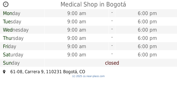
Medical Shop
Carrera 9 #61-08, Bogotá
Pharmacy
read more
625 m
Pharmacity Chapinero
Colombia
Pharmacy
read more
627 m
Droguería Superpharma Av Chile
Avenida Calle 72 #10-3, Bogotá
Pharmacy
read more
643 m
Drogueria Séptima
Carrera 7 #60-73, Bogotá
Pharmacy
read more
688 m
Superpharma
Carrera 9 #72-81, Bogotá
Pharmacy
read more
709 m
Tienda Esotérica Caminos De Esperanza
Bogotá
Pharmacy
read more
1.07 km
Farma Stop Plus Droguería
15, Calle 72a #20, Bogotá
Pharmacy
read more
📑
all categories
Accounting
Administrative area level 1
Administrative area level 2
Airport
Amusement park
Aquarium
Art gallery
Atm
Bakery
Bank
Bar
Beauty salon
Bicycle store
Book store
Bowling alley
Bus station
Cafe
Campground
Car dealer
Car rental
Car repair
Car wash
Casino
Cemetery
Church
City hall
Clothing store
Colloquial area
Convenience store
Country
Courthouse
Dentist
Department store
Doctor
Electrician
Electronics store
Embassy
Establishment
Finance
Fire station
Florist
Food
Funeral home
Furniture store
Gas station
General contractor
Grocery or supermarket
Gym
Hair care
Hardware store
Health
Hindu Temple
Home goods store
Hospital
Insurance agency
Intersection
Jewelry store
Laundry
Lawyer
Library
Light rail station
Liquor store
Local government office
Locality
Locksmith
Lodging
Meal delivery
Meal takeaway
Mosque
Movie rental
Movie theater
Moving company
Museum
Natural feature
Neighborhood
Night club
Painter
Park
Parking
Pet store
Pharmacy
Physiotherapist
Place of worship
Plumber
Point of interest
Police
Political
Post office
Premise
Real estate agency
Restaurant
Roofing contractor
Route
Rv park, camping
School
Shoe store
Shopping mall
Spa
Stadium
Storage
Store
Subpremise
Subway station
Supermarket
Synagogue
Taxi stand
Train station
Transit station
Travel agency
University
Veterinary care
Zoo
administrative area level 3
sublocality level 1
↑