Premise nearby EDIFICIO MIRAMUNDO
Colombia
Premise nearby EDIFICIO MIRAMUNDO
EDIFICIO MIRAMUNDO
Calle 76 #49-08, Barranquilla, Barranquilla Kolumbien
contacts phone
:
+57
Latitude:
10.9988999
, Longitude:
-74.8087154
read more
nearest Premise
72 m
Edificio Cra 49 con Calle 75
Carrera 49 #75-42, Barranquilla, Barranquilla
Premise
read more
116 m
Beverly Hills
Barranquilla
Premise
read more
220 m
Centro Ejecutivo 76
Calle 76 #50-102, Barranquilla
Premise
read more
284 m
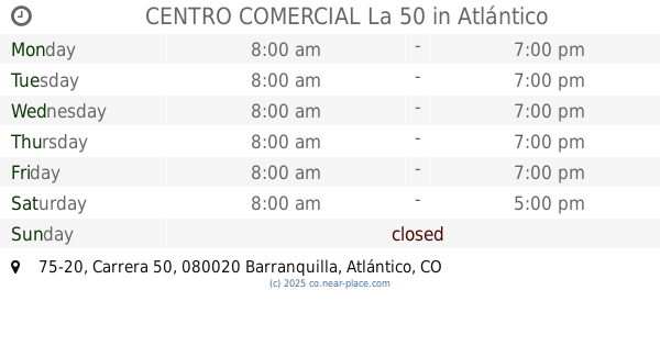
CENTRO COMERCIAL La 50
Centro Comercial La 50, Carrera 50 #75-20, Barranquilla
Premise
read more
327 m
Edificio paymana
Carrera 49c #74-26
Premise
read more
327 m
Edificio paymana
Carrera 49c #74-26, Barranquilla, Barranquilla
Premise
read more
372 m
Edificio Nueva Venecia
Carrera 50 ##75 - 31, Barranquilla
Premise
read more
391 m
Centro Empresarial La Previsora
Carrera 51B #79-136, Barranquilla, Barranquilla
Premise
read more
398 m
El Palomar
Carrera 52 #75-27, Barranquilla, Barranquilla
Premise
read more
428 m
Silvia Tcherassi
Barranquilla
Premise
read more
471 m
Lab. Clinico Pasteurs
Barranquilla
Premise
read more
489 m
Edificio Centro Financiero Asafin
Centro Financiero Asafin, Carrera 53 #75-85, Barranquilla, Barranquilla
Premise
read more
507 m
Parqueadero
Barranquilla
Premise
read more
537 m
Edificio Comercial
Carrera 53 #74-49, Barranquilla, Barranquilla
Premise
read more
550 m
CV Noticias
Barranquilla
Premise
read more
586 m
Centro de Servicio Tigo
Barranquilla
Premise
read more
597 m
Acropolis
Barranquilla
Premise
read more
717 m
Parqueadero
Altos Del Prado
Premise
read more
733 m
La Jaula V. Country
Altos Del Prado
Premise
read more
938 m
Home Club
Barranquilla
Premise
read more
965 m
Generali Colombia
Barranquilla
Premise
read more
1.019 km
Edificio Fincar
Carrera 57 #72-25, Barranquilla, Barranquilla
Premise
read more
1.188 km
UNE
El Golf
Premise
read more
1.237 km
Home Mart
Barranquilla
Premise
read more
1.318 km
Conjunto Residencial La 76
La Concepcion
Premise
read more
📑
all categories
Accounting
Administrative area level 1
Administrative area level 2
Airport
Amusement park
Aquarium
Art gallery
Atm
Bakery
Bank
Bar
Beauty salon
Bicycle store
Book store
Bowling alley
Bus station
Cafe
Campground
Car dealer
Car rental
Car repair
Car wash
Casino
Cemetery
Church
City hall
Clothing store
Colloquial area
Convenience store
Country
Courthouse
Dentist
Department store
Doctor
Electrician
Electronics store
Embassy
Establishment
Finance
Fire station
Florist
Food
Funeral home
Furniture store
Gas station
General contractor
Grocery or supermarket
Gym
Hair care
Hardware store
Health
Hindu Temple
Home goods store
Hospital
Insurance agency
Intersection
Jewelry store
Laundry
Lawyer
Library
Light rail station
Liquor store
Local government office
Locality
Locksmith
Lodging
Meal delivery
Meal takeaway
Mosque
Movie rental
Movie theater
Moving company
Museum
Natural feature
Neighborhood
Night club
Painter
Park
Parking
Pet store
Pharmacy
Physiotherapist
Place of worship
Plumber
Point of interest
Police
Political
Post office
Premise
Real estate agency
Restaurant
Roofing contractor
Route
Rv park, camping
School
Shoe store
Shopping mall
Spa
Stadium
Storage
Store
Subpremise
Subway station
Supermarket
Synagogue
Taxi stand
Train station
Transit station
Travel agency
University
Veterinary care
Zoo
administrative area level 3
sublocality level 1
↑