Restaurant nearby Brasas Huilences
Colombia
Restaurant nearby Brasas Huilences
Brasas Huilences
Cale 7 #2-98, Centro, Neiva Colombia
contacts phone
:
+57
Latitude:
2.9252627
, Longitude:
-75.2903275
read more
nearest Restaurant
422 m
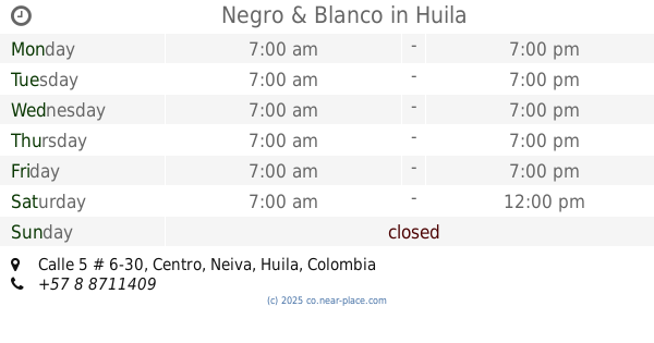
Negro & Blanco
Calle 5 # 6-30, Centro, Neiva
Restaurant
read more
428 m
Llamarada
Carrera 5 No. 2-92, Centro, Neiva
Restaurant
read more
435 m
Mecatos
Neiva
Restaurant
read more
497 m
Restaurante Gran Vinos
45 #2a-185 a 2a, Carrera 1, Neiva
Restaurant
read more
502 m
Tradicional
Carrera 3 #11-100, Neiva
Restaurant
read more
517 m
Barriles de La Sexta
Carrera 6 #10-21, Centro, Neiva
Restaurant
read more
539 m
Azafrán
#6-2 a, Calle 10 #6130, Neiva
Restaurant
read more
593 m
El Sazon Casero
Calle 7 #8 27
Restaurant
read more
643 m
sanagusto
Calle 8 #8-62
Restaurant
read more
784 m
Donatello
Carrera 10 #8-47, Altico
Restaurant
read more
848 m
TG Burguers Parrilla
Carrera 9, Neiva
Restaurant
read more
868 m
Fabrika de Pollo
Carrera 9 #40-34, Chapinero, Neiva
Restaurant
read more
944 m
Telepizzato Me Gusta Mas
Avenida La Toma No.4-70, Neiva
Restaurant
read more
947 m
Vaquería Burger-Parrilla
a 12-95, Carrera 9 #12-1, Neiva
Restaurant
read more
960 m
Guantanamo Restaurante - Bar
Calle 7 No.121, Neiva
Restaurant
read more
969 m
Restaurante y Vinos El Sazon del Mar
Carrera 9 ##11- 32, Neiva
Restaurant
read more
990 m
Los Tres
Calle 6 #12-54, Altico, Neiva
Restaurant
read more
1.014 km
Rinnos Pizza
Avenida La Toma No 12-49, La Toma, Neiva
Restaurant
read more
1.046 km
Kunfu Panda
Carrera 13 No. 71a 7-63, Neiva
Restaurant
read more
1.059 km
La Puerta Grande
Calle 7 No13-10a 13-124, Neiva
Restaurant
read more
1.109 km
Zoologico
Avenida La Toma, Neiva, Neiva
Restaurant
read more
1.109 km
Zoologico
Avenida La Toma
Restaurant
read more
1.123 km
Marmoreo - Cultura Hecha Carne
Carrera 9 #1463, Neiva
Restaurant
read more
1.164 km
Asadero Friky
Carrera 7, Bogotá
Restaurant
read more
1.167 km
URBANO
Carrera 13 No. 12-47, Ahico
Restaurant
read more
📑
all categories
Accounting
Administrative area level 1
Administrative area level 2
Airport
Amusement park
Aquarium
Art gallery
Atm
Bakery
Bank
Bar
Beauty salon
Bicycle store
Book store
Bowling alley
Bus station
Cafe
Campground
Car dealer
Car rental
Car repair
Car wash
Casino
Cemetery
Church
City hall
Clothing store
Colloquial area
Convenience store
Country
Courthouse
Dentist
Department store
Doctor
Electrician
Electronics store
Embassy
Establishment
Finance
Fire station
Florist
Food
Funeral home
Furniture store
Gas station
General contractor
Grocery or supermarket
Gym
Hair care
Hardware store
Health
Hindu Temple
Home goods store
Hospital
Insurance agency
Intersection
Jewelry store
Laundry
Lawyer
Library
Light rail station
Liquor store
Local government office
Locality
Locksmith
Lodging
Meal delivery
Meal takeaway
Mosque
Movie rental
Movie theater
Moving company
Museum
Natural feature
Neighborhood
Night club
Painter
Park
Parking
Pet store
Pharmacy
Physiotherapist
Place of worship
Plumber
Point of interest
Police
Political
Post office
Premise
Real estate agency
Restaurant
Roofing contractor
Route
Rv park, camping
School
Shoe store
Shopping mall
Spa
Stadium
Storage
Store
Subpremise
Subway station
Supermarket
Synagogue
Taxi stand
Train station
Transit station
Travel agency
University
Veterinary care
Zoo
administrative area level 3
sublocality level 1
↑